Geoarchaeology
Geoarchaeology uses earth science, environmental archaeology, and palaeoecology methods to understand how people interacted with landscapes in the past.
We provide advice, assessment, surveys, and mitigation strategies to help clients manage archaeological and palaeoenvironmental risk. We also provide a wide range of services such as:
- Deposit modelling
- Geoarchaeological desk-based assessment
- Window sample/borehole and test pit surveys
- GI Monitoring
- Palaeoenvironmental analysis; pollen, insects, plant macrofossils, diatoms, ostracods and forams
- Radiocarbon dating as well as OSL (Optically Stimulated Luminescence)
- On site specialist sampling
Our Conservation services also provide hydrological modelling, geochemical analysis, and assessment of deposit and artefact preservation.
These methods allow us to better understand a site’s depositional sequence, identify areas of archaeological potential, and establish a baseline for the burial environment.
Our team works across the UK to provide specialist geoarchaeological services to a range of clients and stakeholders.
Geoarchaeology Case Studies
National Trust's Wetland Restoration Scheme
For the National Trust’s wetland restoration scheme at Sandilands, Lincolnshire, we identified an early Neolithic peat deposit. Palaeoenvironmental analysis helped establish the character of the landscape prior to marine transgression.
Our work within the aggregate extraction industry within the Trent valley has provided a significant contribution to the understanding of landscape change throughout the Holocene. This is critical to establishing the presence and preservation of archaeological deposits within both a floodplain wetland and a dryland valley side context.
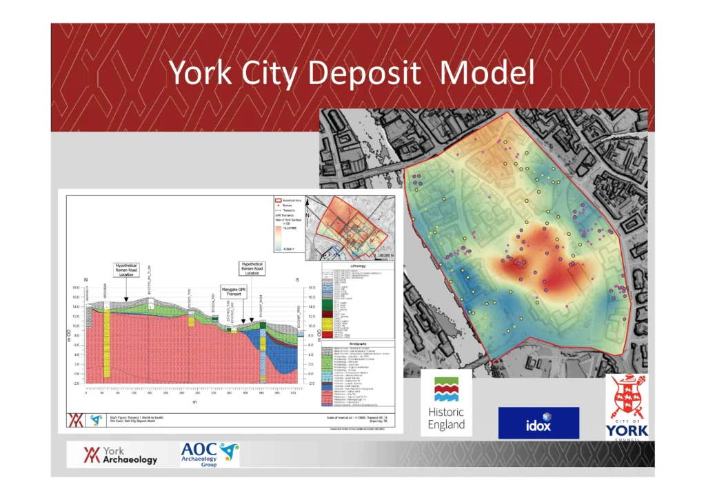
In addition to our commercial work, we are engaged with the research community. With our partners at AOC Archaeology, we are working for City of York Council on the Historic England funded York City Deposit Model Project.
The York City Deposit Model Project
York Archaeology, in partnership with AOC Archaeology, are collaborating on the York City Deposit Model Project, for the City of York Council, funded by Historic England. The original model, created in 1991, mapped layers of archaeological deposits across the city centre.
Since then, archaeological and geoarchaeological practices have evolved, and deposit modelling has become a key part of heritage management in York. In consultation with the City Archaeologist, Claire McCrae, we are updating the existing model’s format and content housed in the Historic Environment Record (HER). The new model integrates 30 years of archaeological records, making future updates easier and efficient.
One innovative feature is the creation of 3D visualisations of archaeological deposits. These models will guide future excavations, improve post-excavation analysis, and provide a dynamic model for managing York’s nationally significant archaeological heritage.
The model will also provide lithological and stratigraphic data to support heritage management decisions and will be easy to share across archaeological teams. It will be accessible online, allowing the public to explore York’s historical layers.